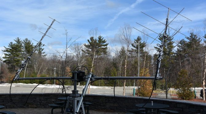
We recently did a Tech Night on Building and Operating a Satellite Ground Station. As part of my portion of our Tech Night presentation, I recorded several LEO Satellite Contacts and made videos showing the operation of the computer controlling our Satellite Station 2.0 during these contacts. These videos give an idea of what it’s like to operate through LEO satellites.
I wanted to share some information about our tracking our High Altitude Balloon as it flies. Our balloon will carry’s a GPS receiver and a 2m APRS Transmitter.
HAB Flight Platform
The on board APRS transmitter will operate on the Amateur Radio standard terrestrial APRS frequency of 144.390 MHz and will transmit our HAB’s position, heading, speed, altitude and other telemetry data every minute during the HAB’s flight. The transmitter is battery-powered and generates a 250 mW signal into a dipole antenna suspended from the HAB’s flight platform. The HAB will use N1FD-11 as its call sign.
Based upon online HAB flight prediction calculators that we have been using, we expect the HAB’s flight to last a little less than 2 1/2 hours. The HAB should reach an altitude of over 102,000 ft before the balloon bursts and the parachute on the flight platform brings it back to the ground at a safe speed. The above prediction will likely change as we get closer to an actual launch but most predictions have our HAB traveling approximately 100 km between its takeoff point and landing.
HAB APRS Packet Information
Aprs.fi will also store and display a copy of all of the APRS AX.25 packets transmitted by the HAB during its flight. Of particular interest to the STEM element of the flight will be the Balloon’s data on atmospheric temperature and pressure conditions at different altitudes.
All you need to track our HAB during its flight is Internet access and a web browser. Just click on one of the aprs.fi links here to see the HAB’s current location and altitude. If you have an APRS ground station, you may also be able to receive our HAB’s telemetry directly during the flight.
We need cloud cover which is less than 50% and ground wind speeds below 15 mph to launch our HAB. Will will post a final launch date and plans in the Youth Forum on our website. Our next possible launch window is on Saturday, June 3rd. We are all pulling for good weather so that we can launch!
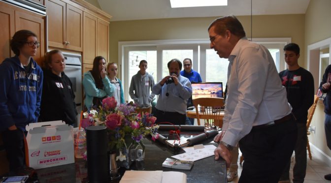
On May 6, members and friends of the HAB (High-Altitude Balloon) Project gathered at Anita (AB1QB) and Fred’s (AB1OC) QTH for an open house to introduce the students participating in our project to amateur radio and the HAB itself. The weather wasn’t exactly cooperating with us, as rain was in the forecast. In fact, this was supposed to be the week before our actual launch so we could do some prep work with the kids. Fate had other ideas for the launch, however, as it was postponed due to more rain and has been since rescheduled to June 3.
Among the students there, we had representation from Merrimack High School, Bishop Guertin High School, and our independent group of which Abby (KC1FFX) and Connor (KC1GGX) made up 2/3 of the students.
Teachers (and a student) from Merrimack and Bishop Guertin
Beginning around 9 am, we crowded into the kitchen to have Fred introduce the agenda for the day.
Gathering around the table
After showing off the HAB, the components, and explaining what everything did and how it was interconnected, we broke off into three teams. The first would tour the illustrious shack, the second would get a primer on antennas and towers in the backyard, and the third would brave the elements and go on a foxhunt.
A crew going on a Fox Hunt
After each group was able to accomplish all three activities, we then invited the kids to make some QSOs in the shack and/or make some QSOs with Fred and Anita’s amateur satellite station v2.0. (I, myself, had made my first two satellite QSOs earlier that morning. A VERY cool station, indeed). A few were definitely nervous and mic shy, but most stepped up and seemed truly amazed (bewildered) that they could talk to some random person in some random corner of the globe.
By about 2 pm, there seemed to be expressions of fatigue on the young faces, and it seemed a natural time to conclude the day. All in all, it seemed the kids truly were excited about amateur radio and the HAB. We look forward to working with them in future phases of our HAB project and hope this is something that many of these freshmen can turn into a serious senior science project when they’re looking ahead towards graduation in a few years. (And perhaps, we’ll get some of them licensed too!)
We use cookies to ensure that we give you the best experience on our website. If you continue to use this site we will assume that you are happy with it.


 from Merrimack and Bishop Guertin")

