Category Archives: Newsletter

Nashua Area Radio Society Newsletter Articles. You can find an archive of our Newsletters on our website.

Field Day IT Test – Stations, Network and Logging Computers

Dave Merchant K1DLM, our Field Day chairman, is bringing some 21st Century radio and computer technology to our Field Day setup this year. There are several aspects to this new component of our Field Day plans and the associated IT Test including –

  • Two Flex-6700 Software Defined Radios running over a network  for our new Digital and enhanced GOTA Stations
  • An on-site WiFi Network to enable using the N1MM+ Logger in network mode for sharing of log information, station activity, real-time scores, and messages
  • A central Score Board and Club Information Computer in our public information tent
2017 Field Day Site - Upper Field Layout
2017 Field Day Site – Upper Field Layout

We will again be holding our 2017 Field Day operation at the Hollis-Brookline High School in Hollis, NH. We are planning on using the upper baseball field area as our main operating location. We have decided to add a third tower this year and locate it on a soccer practice field which is situated several hundred feet away from our main operating area. All of our antennas and equipment will lie within the required 1000′ circle but the third tower would situate those operating at that location away from the rest of our group. Dave’s solution to this problem was to set up a network and operate two Software Defined Radios (SDRs) at the lower site remotely from our location on the upper field.

Dave has enlisted club member Piece Fortin, K1FOP to be our IT Chairman for Field Day this year. Pierce has been instrumental, along with Dave, in the planning and testing of all of this new technology. Pierce and Dave have a great deal of networking and IT experience and knowledge and we could not have put together what is described here without them.

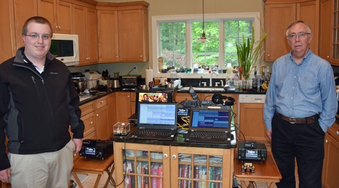
Dave K1DLM, Pierce, Hamilton K1HMS, Mike Ryan K1WVO, Anita AB1QB, and I have gotten together multiple times to set up and test all of this new technology. I wanted to share some more about the equipment and the associated testing (which has been staged in the kitchen at our QTH – thank you, Anita!).

We began the testing process by setting up our 20m CW station.

IT Test - 20m CW Station Test
20m CW Station Test

This station uses an Elecraft K3S Transceiver, a K1EL WinKeyer and the N1MM+ Logger running on a Windows 10 Laptop PC. We used this station to get our basic N1MM+ setup including our Field Day CW keying macros right.

IT Test - 40m SSB Station Test
40m SSB Station Test

Next came our 40m SSB station. This setup uses an Icom IC-7300 Transceiver and allowed us to set up and test N1MM+ on the fly audio macro recording and playback. All three of our SSB stations will have on the fly recording and playback capability which will allow each of our SSB operators to record and use a custom set of audio macros.

IT Test - Digital Station Test
Digital Station Test

Next came our Digital Station. This station uses one of the two remote Flex-6700 SDRs.

IT Test - Remote Flex-6700 SDRs and Antenna Switch
Remote Flex-6700 SDRs and Antenna Switch

Dave, K1DLM put together a really nice package for the two Flex-6700 SDRs and associated equipment which will be located on the lower field. He used a rack system to mount the two SDRs, power supplies, a three-band Tri-plexor, a set of bandpass filters for 80m, 40m, 20m, 15m, and 10m and a 403A 8×2 networked antenna switch. This setup allows either of the two SDRs to share the tri-band yagi or the 40m and 80m Inverted-V antennas on the tower on the lower field and operate on any of the 5 available HF bands. Antenna and filter switching automatically track the frequencies of the two SDRs making the setup simple to use.

Digital Station Second Display - SmartSDR & More N1MM+
Digital Station Second Display – SmartSDR & More N1MM+

The Digital Station’s remote SDR will be operated using a SmartSDR client running on the Digital Station laptop PC. This station will have a second monitor to better accommodate all of the windows associated with it.

IT Test - Digital Station Main Display - N1MM+
Digital Station Main Display – N1MM+

The main display associated with the Digital Station will run decoders for all PSK and RTTY modes. The ability to decode multiple PSK signals simultaneously and multiple RTTY decoders are available. The Digital station also acts as the N1MM+ master station in our Field Day setup for all of the other stations which use N1MM+.

IT Test - Satellite Station Test
Satellite Station Test

Our Satellite Station 2.0 was also added to the test setup. It uses a MacBook Air laptop running MacDoppler to control the antenna rotators and the Icom IC-9100 Transceiver which are part of our Satellite Station. A Windows 10 Surface Pro computer is included which runs N1MM+ and provides logging and other network functionality for our Satellite Station.

IT Test - GOTA Station
GOTA Station Test

We also tested our GOTA station which uses the second Flex-6700 SDR and a FlexRadio Maestro to provide a more conventional “buttons and knobs” interface for our GOTA operators to use. This station will also have a laptop PC running N1MM+ for logging.

IT Test - Scoreboard Computer
Scoreboard Computer

We also build and tested a Scoreboard PC. This computer will be located in the Public Information tent at Field Day and will be connected to a large display. It will show our real-time score, QSOs being logged as they are made and other useful information about our Field Day operations. This computer will also continuously play videos from our Club Video Collection and will provide access to IP video cameras which monitor the tower and equipment on the lower field.

IT Test - Pierce, K1FOP and Hamilton, K1HMS Testing CW Stations
Pierce, K1FOP and Hamilton, K1HMS Testing CW Stations

Our networked N1MM+ test bed contained at least one station of each type (CW, SSB, Digital, Satellite, and GOTA) that will be part of our Field Day setup this year. The Station Masters for the additional CW and SSB stations came by to test their setups using the test bed.

IT Test - Field Day Networking System
Field Day Networking System

The networking system which Dave and Pierce built is central to all of the technology described here. All of the gear is mounted in a single rack which will be located on the upper field during Field Day. The setup includes a Firewall/DHCP server, a commercial grade outdoor WiFi access point, a 4G LTE modem for Internet access, an Ethernet Switch, and a UPS power supply.

IT Test - MoCA Data Link Cable
MoCA Data Link Cable

The upper and lower fields at our Field Day site are separated by several hundred feet. A thick line of trees between the two locations raised concerns about connecting the upper and lower sites using WiFi. Pierce came up with a great solution to this problem – we will be using MoCA Data Modems and RG6 Quad Shield 75 ohm Coax Cable to provide a 10 Mbps data link between the two sites. We tested the MoCA link using a much longer run of coax cable then we will need to use at Field Day and confirmed full 10 Mbps throughput.

N1MM+ Talk Window
N1MM+ Talk Window

Our networked N1MM+ setup will allow any station in our setup to send messages to everyone who is operating at Field Day. We can use this capability for important communications like “lunch is ready!” or “I need help from Pierce (our IT chairman) on the 40m SSB station”, or “The 6m band is wide open!”.

Our GOTA and Digital stations will be located together in the same tent and will provide our Field Day 2017 visitors to see and use 21st-century Amateur Radio technology to make contacts. We are expecting young people who participated in our club’s High-Altitude Balloon project and from other local schools where we have done Amateur Radio activities to attend. In additional to being a learning opportunity for all of us in the Nashua Area Radio Club, we hope that the state of the art technology that we are using will generate interest among our visitors.

Fred, AB1OC

Hashtags: #ARRLFD #N1FD

MT. Hale and 30 Meters (in the rain)

MT. HALE and 30 METERS QRP

The White Mountains National Forest

Dennis, K1LGQ

Dennis Marandos – K1LGQ

The trip to the mountain had been planned four weeks in advance and I was to guide my seventeen-year-old son, Justin and his two friends, on a Saturday hike in the White Mountains in northern New Hampshire. The date was May 27th and it was agreed that I would bring along my radio gear because I am the driver and the guy who knows how to climb Mt. Hale. It was agreed that Justin wouldn’t complain when I took an hour off from our climb for me to string a dipole and work some DX just waiting for my QRP signal east and westward wound. My son with his two friends packed into dad’s car and headed due north driving one hundred twenty miles to the White Mountains National Forest. For those people who are unfamiliar with the North Country, New Hampshire has a great number of mountains along with the other five New England states, and NH, in fact, has forty-eight foothills that are 4,000 feet or better. This may seem quite mundane, however, hiking and “hill topping” with a handy on these ridges is “primo” in this part of the country.

The gang arrived at Zealand trail, Halebrook & Lend-A-Hand trails at 9:15 ready to zoom up the miles of pure fun. I had my handy, my 30 meters “30-40” home brew rig with me and a pretty heavy 12-volt gel-cell battery. I knew the kids, who were all 17 years old, would complain if I asked them to carry my gear, so I opted to carry a ‘large’ knapsack with water, small lunch, extra socks, sweatshirt, and long pants by myself. The backpack was pretty heavy, but you have to know what to expect for weather when climbing any mountain. I also had my key, earphones, and dipole in a waterproof bag neatly stored till we reached the top.

As we climbed, the early morning sun was vibrant as in just about any corner of the U.S., but when the clouds started rolling in on our climb at ten in the morning, the weather was truly undefined for that day. Sure, you can listen to the National Weather stations, but the NWS tends to extend their prognostications to include everything, just in case anybody should question their forecasts. The sky was navy blue and the air temperature was a cool 65 degrees—just right. The precipitation was damp from the previous night and we were headed onto an easy climb, and total time to the top was estimated at about two hours or less.

I couldn’t wait till we got to the top of Mt. Hale and do some QRP operating. The boys were twenty feet ahead of me, throughout the entire climb, and they had a much lighter backpack. I kept insisting that they shouldn’t run so often or they would be out of strength by the time they reached the top. Right! I am talking to three teenage boys! That was an exasperation of time.

As we drew nearer the top, you could feel the air turn denser and the temperature dropped a bit more. The tree line was thinning, but never to the point of an overall rock surface. The total height of Mt. Hale is 4,054 feet, and the trail began at the 2,100-foot level. I was psyched about operating from the mountain and kept thinking of how I would set up my portable station. Over and over I kept asking myself which direction way was south and which was west. I wanted especially to work the west coast and Europe if I could

Finally, when the crew was ten feet away from where the old ranger station used to be on top of Mt. Hale, I yelled to the ghosts of the mountain that I was coming, ready or not. I wanted to clear the area and not have something senseless happen like have my RF flow into the absorbing rocks nearby—never to be heard from again. At this moment, the sky had turned pretty gray and the temperature must have dropped another ten degrees since we started our excursion from the base, but worst of all was the intimidating spitting of droplets on my glasses. This was New England, and if you particularly don’t like the weather, just wait a short while and the elements will change. I knew what to do, after all–I am Mr. Cool and a smart Dad. You don’t think for a minute that I would bring my son and two of his friends on a hike and have the weather turn on us?

The environment factors were increasing and I knew something was up, but I was resolute to get my station up and operating. The boys wanted to eat their lunch first, and being the group leader, I suggested the boys not eat and drink too fast for they might get dizzy after a strenuous climb. Again, I forgot who I was talking to. Out came their bags of Nachos, potato chips, and heavy duty caffeinated Coca Cola along with sugar desserts made with chemicals I couldn’t even pronounce on the side of the bags. Ugh! Give me a break, but I insisted we set up my station real soon, so the boys could walk around a bit while I did some CW.

Fate has a way of presenting farrago weather to the unsuspecting neophyte in the wilds. No sooner did I reach into my knapsack for my radio gear, and no sooner did I uncurl my dipole, it started to RAIN! I mean, this was the mother of all storms and Armageddon was just a warm up. The boys had brought jackets, with rain hoods, while I only had a hand towel, socks, and a sweatshirt. It didn’t look like the rain was going to stop and I motioned to the boys to just sit tight for a few minutes while this ‘bimbo’ rain cloud passed overhead. Fifteen minutes had gone by and the rain was filling anything that could hold moisture. It looked like the hike was a wash and we started down another trail. Yikes! I wanted to operate!

The climb down the mountain is always easier, but nastier because gravity tends to push forward. I instructed the boys to walk slowly so they wouldn’t slip and roll the rest of the way, but there I go again…I forgot who I was talking to. Three teenage boys, who had their fill of whatever chemicals were in their lunch, bouncing down the side of Mt. Hale and having a pretty good time. I kept my vociferation comments within their ear shot and reminded them I had the keys to the car, which was another six miles away. Okay, perhaps a half mile away.

I am pretty sure the troops hadn’t traveled twenty minutes down the mount when the sky opened with beautiful rays of the sun and bright patches of azure blue. I couldn’t believe it! The weather was perfect and here I was going the wrong direction. Great! Do I ask the guys to turn around and head back to the summit so I can do a little CW and have my time, or do I keep going down because they’re running at a gallop and I am not? Superfluous to say, we kept descending more and more, side-stepping the six-inch puddles of water and four foot wide streams in our path.

After we got to the car and unpacked our gear from our backpacks, my son and his two friends said they had a remarkable time climbing the mountain and asked if they could do it again…if I wanted to take them.  They even gestured that they would carry my gear next time. I gasped for breath and managed to grin from ear-to-ear and said, “You’re on!”

What I thought was a hike into hell, a death march straight up, the torture of climbing a wet mountain—the boys thought was a pretty COOL episode. What other dads would have bothered to take the ‘guys’ onto a mountain, have twenty-foot visibility at the top and gracefully become thoroughly soaked? They had fun, but it bordered on what the definition of fun was. I had to say I sure did miss operating at 4,054 feet on 30 meters, but they did say they would carry my gear next time. I hope my marine battery won’t be too heavy for them. YES!

~~~~~~~~~~~~

Post Script: This hike took place a few decades ago and my son is much older now. However, the facts remain and it still lingers in my mind what a “wonderful” day we had despite the little rain that fell. I certainly hope I can “puff” all the way to the top and try again.

Crossing A HAB Off The Bucket List….

Back in 2010, I was a postdoc in the particle theory group at National Taiwan University in Taipei. I was working with a buddy, a German fellow, and in the middle of talking about made up particles (actually they’re real) in imaginary time (this is an actual “thing”), he showed me a neat YouTube video that he found. As we watched, we saw two young fathers design and launch a high altitude balloon (HAB) to stimulate interest in their very young sons. Of course, the best part of this entire endeavor was the video footage they recorded during the ascent/descent. It was awesome; in the original definition of the word. I immediately developed HAB envy and wanted to do this myself. I told my future XYL, Anne, about this and she said if I came back to the U.S., she would help me design one.

Fast-forward to 2011. I came back home, and though Anne offered to help, I was adjusting to a new job in VA and had zero time to dedicate to it and coupled to that, zero money. The dream would have to wait.

Fast-forward to early winter 2016 (I think it was early 2016). Fred, Anita, Jamey, Tony, myself, and others were sitting at the Dartmouth-Hitchcock facility during one of our Youth Days. We had just finished lunch and were brainstorming ideas to engage young people in amateur radio. Fred had mentioned, how about a high-altitude balloon carrying APRS? Bing. Bang. Boom.  That was all I needed to hear. This was the opportunity literally right in front of me to check the box. So, as you can guess, I was in.

The team had a lot of work in front of us. Some of you have heard us proselytizing the good word at our meetings. This whole project would not work if it were just about a solitary, singular balloon launch. There had to be a hook; had to be something that would allow us to continually interact with the potential participating students. What we had decided was to create a STEM opportunity in the classroom. For those of you unfamiliar with STEM, it stands for Science, Technology, Engineering, and Mathematics. It represents a body of activities and teaching to foster and nurture this type of education in students. It takes the form of FIRST robotics, programming courses for kids, DIY electronics for kids. You name it, it’s probably a “thing” already. So this is what we tasked ourselves with.

To move forward, we had to establish a potential curriculum and target schools that we could work with and hopefully engender a long-lasting partnership with. The ideal case scenario we envisioned would be, to begin with, students as freshman and work with them until graduation; maybe even getting a senior thesis out of it.

I won’t bore you with all the details, but to name a few, we had bi-monthly WebEx conversations to discuss how to move forward, solicited schools, developed a presentation schedule, created a TON of PowerPoint slides to be presented in the classroom, ordered and tested the HAB and its components, organized an Open House at Fred/Anita’s QTH, and of course figured out a launch date — let’s talk about that next.

Ah, launch time. The culmination of 7+ years of waiting was actually going to happen. I could measure time by prepending the phrase “T-minus” to my system of units — Pretty cool. The morning of, many of us gathered at the requisite spot; the anticipation was pretty palatable. After the exact launch locale was ascertained, we prepped and began to inflate the balloon. Spoiler alert: We under-filled the balloon due to a misunderstanding of the instructions from the company which led to a longer flight time. The moment I let the balloon go, I swear my mind went through all the charts I made, all the prep work the team went through, and an overwhelming sense of pride at the accomplishment we achieved.

We quickly cleaned up and adjourned to a local restaurant where we viciously ate our food and just as viciously scoured the interwebz (aprs.fi) to get the latest update of the balloon’s telemetry. Since the update time was about one minute, it was obvious that Einstein’s theory of Special Relativity was at work; each minute felt like an eternity in my reference frame.

Finally, touchdown! In RI. Ok…sure. We predicted SE of Worcester, but it was RI. Fred called me a few times to update me on the HAB’s status after recovery. I asked him to let me know when the data would be available in the Dropbox. When I saw this, I instantly turned to MATLAB and created the following plots from the telemetry data on the flight computer. (Note: It’s update time is every 6 sec, so we get more accurate updates than APRS)

IMHO, I think the most interesting plots are those of the pressure vs altitude of the HAB and the temperature vs altitude. These are fascinating since:

  1. We have theoretical models from NASA with which to compare with.
  2. It’s unfathomable we can record this data THAT HIGH UP with such simple tools.

Below, I’ll only show the results from the ascent. (The descent essentially looks the same). Also, for posterity, I included the NASA predictions which for those of you who are more mathematically minded (all of you, right?!) can sink your teeth into.

High Altitude Balloon

High Altitude Balloon

High Altitude Balloon

What I find fascinating is that the pressure the HAB recorded (shown in blue) lies essentially on top of the NASA predictions (shown in black). Moreover, the temperature shows good agreement qualitatively: namely a sharp decrease until a particular altitude, then it levels off, and finally begins to increase again. Where those boundaries occur differs between NASA and our local measurements from Winchester, NH. But, the trends are the same. Very encouraging. The next most interesting plots are those derived from the telemetry data. The first is the ascent altitude vs time:
High Altitude BalloonThe vertical speed seems to be essentially constant. This makes sense so long as the vertical lift force from the Helium balances out the downward force of gravity. And this is essentially what we are seeing here and is what is modeled by our HAB prediction website. On the way down, the curve looks a bit more interesting:

High Altitude Balloon

Initially, the HAB seems to be accelerating (since there is some curvature to the line until about 240 min of elapsed time), but after it encounters more air as it falls, it seems the parachute is deployed and therefore reaches terminal velocity (e.g. constant speed)


The upshot of all this stuff is I made a TON of plots on launch night (from the APRS data) and the following morning (from the flight computer data) which I have shown here. I won’t bore you with the other results, but there is a wealth of info one can calculate and learn about.

This entire experience has been an absolute pleasure to be a part of on many, many levels. I just hope we, the HAB team of NARC, have begun to inspire some kids in STEM and amateur radio due to our efforts.

Best and 73,

Brian, AB1ZO

Hashtag: #N1FDHAB

Radio Amateurs Developing Skills Worldwide