

We are planning the fourth launch of our High-Altitude Balloon (HAB-4) this Sunday, June 9th between 10:30 am and 11:30 am ET. We will be launching locally from the Hollis-Brookline HS here in Hollis, NH. Read on to learn more about our HAB projects and how to track our HAB while it is in flight.
You can learn more about our HAB projects here on our website and you can view a video about our first three HAB launches above.
High-Altitude Balloon Launch Site and Weather
The weather and Jetstream conditions look good for our HAB-4 launch! The jet stream has finally settled down to a point that will enable us to launch locally from the High-School here in Hollis, NH. Nashua Area Radio Society members and friends are invited to join us for our launch.

We have been working with students at the Hudson Memorial School and Bishop-Guertin High School here in NH. The students and their teachers will handle HAB-4 launch preparations and the launch. Launch preparations will begin on site at 9:00 am ET.
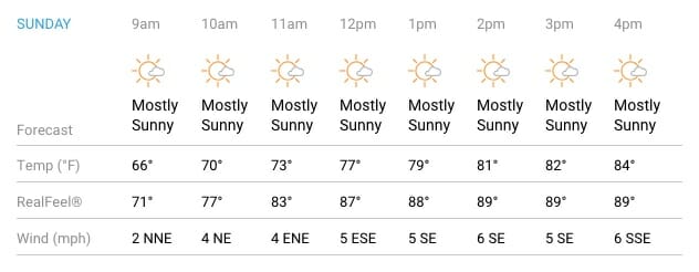
The weather forecast looks great for our launch on Sunday with mostly sunny skies and moderate winds. These conditions should enable us to capture some spectacular video from HAB-4 during its flight! We are also planning to live-stream video from our HAB-4 launch and recovery to the Nashua Area Radio Society Facebook page.
Tracking Our HAB
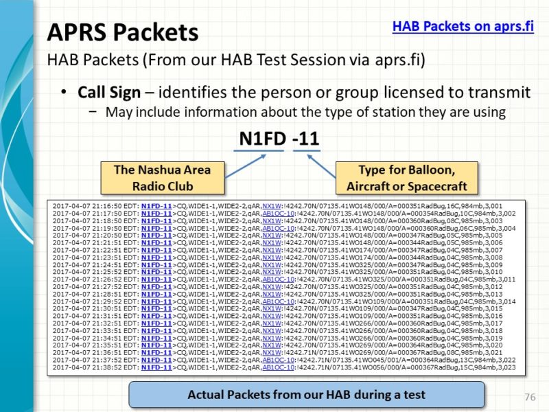
I wanted to share some information about tracking our HAB as it flies. Our balloon will carry a GPS receiver and a 2m APRS Transmitter.
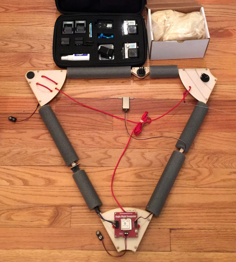
The onboard APRS transmitter will operate on the Amateur Radio standard terrestrial APRS frequency of 144.390 MHz and will transmit our HAB’s position, heading, speed, altitude and other telemetry data every minute during HAB-4’s flight. The transmitter is battery-powered and generates a 250 mW signal into a dipole antenna suspended from HAB’-4s flight platform. HAB-4 will use N1FD-11 as its call sign.
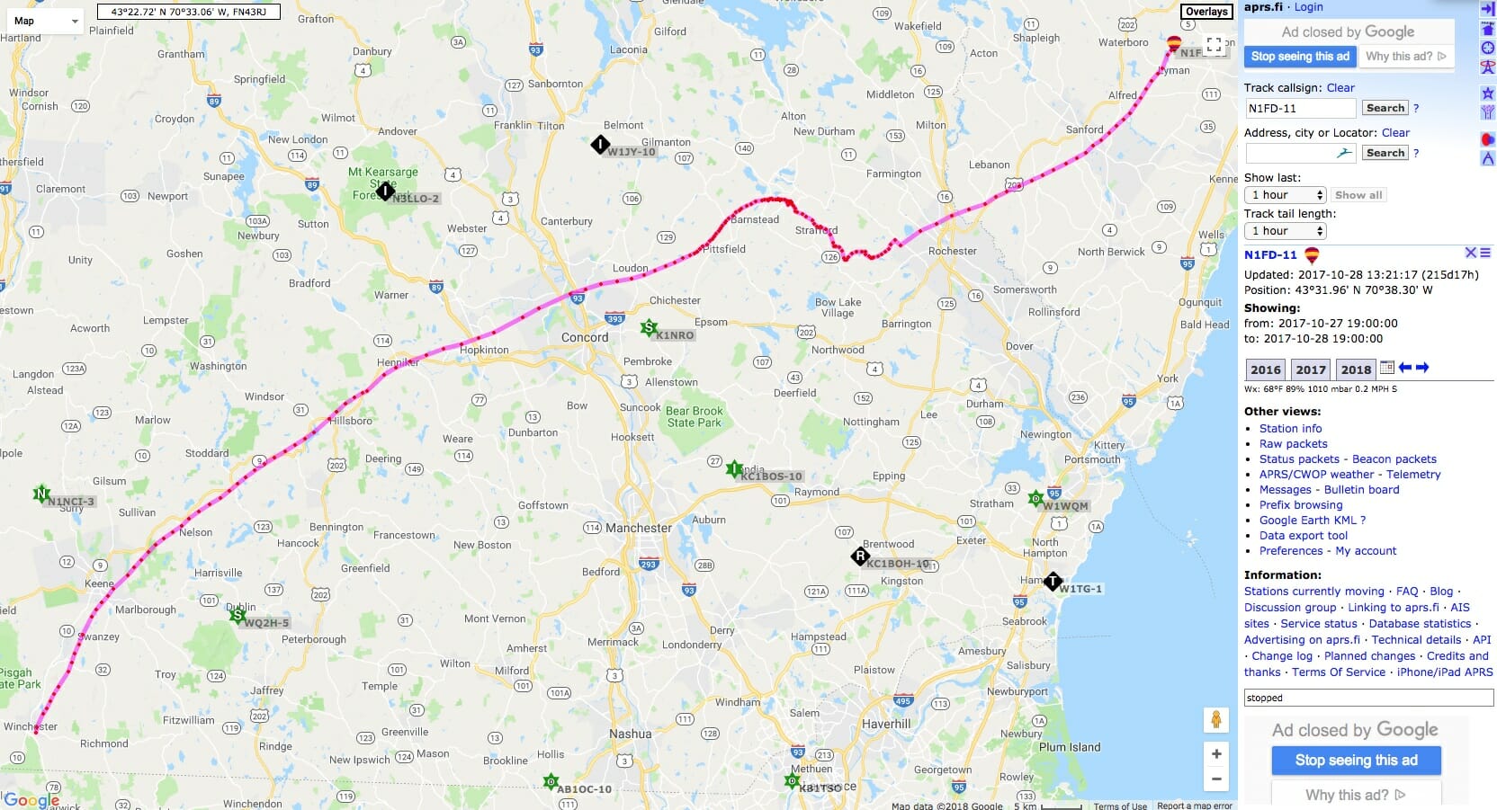
HAB-4’s APRS packets will be picked up by ground-based Digipeaters and iGates and will be relayed to aprs.fi where the HAB’s current location and flight path can be tracked. You can click on the link in the previous line to see HAB-4’s current location and flight track.
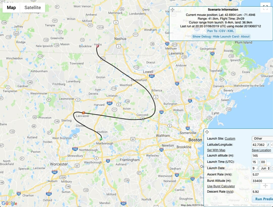
Based upon online HAB flight prediction calculators that we have been using, we expect the HAB’s flight to last a little more than 2 1/2 hours. The HAB should reach an altitude of about 110,000 ft before the balloon bursts and the parachute on the flight platform brings HAB-4 back to the ground at a safe speed. The above predictions will likely somewhat different from HAB-4’s actual flight path. Based upon the predictions, HAB-4 will be traveling approximately 42 km between its takeoff point and landing near Marlborough, MA.
Aprs.fi will store and display a copy of all of the APRS AX.25 packets transmitted by HAB-4 during its flight. Of particular interest to the STEM element of the flight will be the Balloon’s data on atmospheric temperature and pressure conditions at different altitudes.
All you need to track HAB-4 during its flight is Internet access and a web browser. Just click on one of the aprs.fi links here to see HAB-4’s current location and altitude. If you have an APRS ground station, you may also be able to receive HAB-4’s telemetry directly during the flight.
We will post updates on launch plans and the flight in the Youth Forum on our website.
You can join us for the launch. Here’s a map showing how to get to our launch site.
Fred, AB1OC